Equipment & Software for Geophysical Surveys: Design, Manufacture, Support, Supply
ZondST3d — 3D seismotomography interpretation (refracted waves)


ZondST3d is designed for three-dimensional interpretation of seismic tomography data on refracted waves (land, cross-borehole and water variants).
In geophysics, the term seismic tomography is known for a long time. This is due to the fact that one of the main problems in seismology — the inverse kinematics. It consists of determination the velocity structure at a known time path of the refracted waves from source to receiver. Cross-borehole seismotomography is one of the most popular methods in engineering geophysics; it is used for detailed determination of structures’ velocities in interwell space.
The technique of three-dimensional seismotomography means special survey with using of great number of sources and receivers positions. Sometimes number of trace is reach thousand and tens thousand. But in many cases for three-dimensional interpretation it is enough to use the results of a two-dimensional seismotomography observed on several parallel lines.
ZondST3d represents ready solution for seismic tomography, and solves wide range of problems from mathematical modeling and quality control to field data processing and interpretation. Convenient interface and variety of data visualization features allow to solve wide range of geological problems with maximum effectiveness.
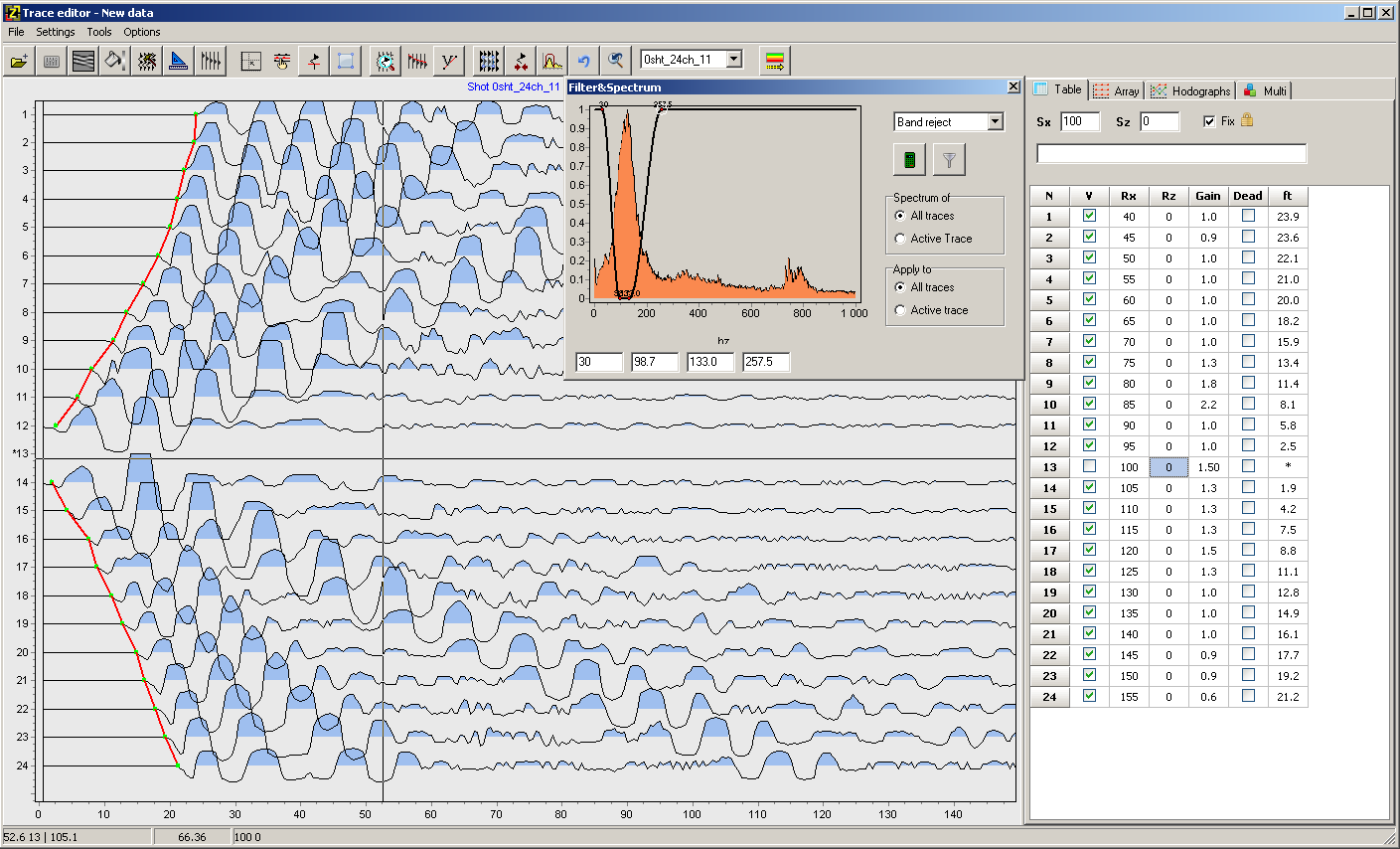
The software consists of two basic modules. One for the first times picking on the seismograms. The second is used for solving forward and inverse problems of seismic tomography.
For the seismograms processing developed a special interface designed to simplify and automate the process of first arrivals picking. Special attention is paid to variety ways of data visualization and simple access to frequently used functions.
Solution of forward problem basis on special ray tracing algorithm of graph theory (Shortest path’s method). This algorithm is characterized by a high-speed calculations, and controlled accuracy.
ZondST3d uses simple and clear data format which allows easily combining various systems of observation, including different variants of the topography setting up and other additional information.
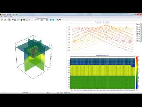
Some variants of three-dimensional model display in the form of various sections and isosurfaces are realized in the program.
Important stage which prevents field measurement is mathematical modeling of velocity structure of work site. Modeling gives a chance to estimate the level of reflected waves first times and to make a choice of optimum parameters of the observation system for decision of formulated geological problem. ZondSt3d has great range of tools for mathematical modeling and analysis of first times field.
As the general task of the program is inversion of velocity parameters, some variants of inverse problem decision are realized in ZondST3d, basic of them are: smoothing inversion — to get smooth model and focusing — to get piece-smoothed model of velocities with depth. While program was designed special consideration given to a priori data accounting. Because of equivalence of inverse geophysical problems, quality of the obtained results strongly depends on the amount of a priori data used. In ZondST3d there is possibility of weights setting for measurements, fixing and limits making of changing features of different cells, using of a priori model as reference in inversion. The robust schemas of noise estimation are realized in the software. There is also possibility to import and display results of measurements by other methods and cross-boreholes data that improved quality of results.
More details on the functionality of the software can be found by downloading the user manual as well as its demo-version or by watching video reviews and tutorials.
ZondST3d overview (5.11.2016)