

Equipment & Software for Geophysical Surveys: Design, Manufacture, Support, Supply
ZondSP2d — 2D Self-potential
Software ZondSP2d is designed for 2D interpretation of self-potential (SP) data.
The SP method is based on studying electric fields that occur in rocks as a result of various physical and chemical processes. In almost any geological setting there are self-potentials of diffusely-absorption and filtering nature exist. And over sulfidized and graphitized rocks one can find much more intensive fields of redox nature. ZondSP2d allows interpreting different types of natural field sources. The choice of source type depends on the task at hand:
- edge source of the redox nature arising at the boundary between electronic and ion conductors, by changing barrier jump at this boundary,
- volume source can be specified by vertical or horizontal dipoles, point sources, as well as dipoles of arbitrary direction.
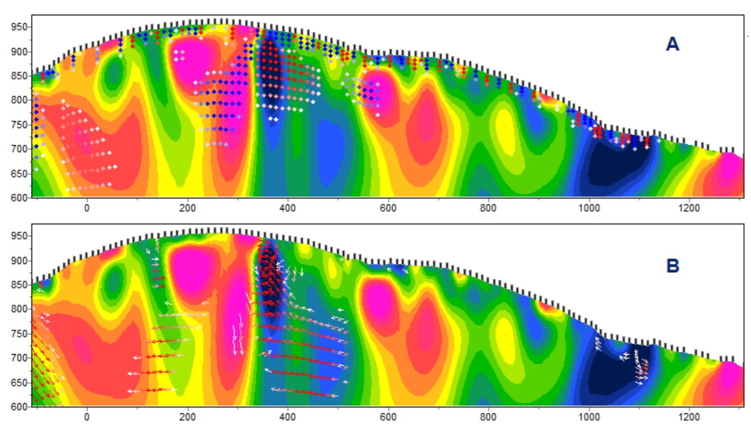
Inversion result for point sources (A), for dipoles of arbitrary direction (B)
- Supports all setups and their combinations with arbitrary gradient and potential setup lines
- Import of field data from text and Excel files
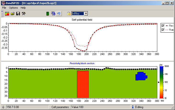
- Taking into account topography
- Constructing a geoelectric section based on polygonal or mesh models
- Import of resistivity model from programs: ZondIP1d, ZondRes2D, ZondMT1D, ZondMT2D, ZondTEM1d, ZondTEM2d
- Polygonal modelling of volumes, source boundaries
- Inversion algorithms: statistical, Occam’s with settings of smoothing, intensity, resolution; robust and parametric
- Memory buffer with up to 5 models
- Approximation algorithm of observed natural fields by a set of elongated objects of different geometry with linear distribution of sources along the strike
- Different options for visualization of field data, models and a priori information
- 3D visualization of sections over a network of arbitrary profiles with the construction of sections for different depth
- Export to raster and vector graphics formats, Excel, Surfer, GeoSoft, AUTOCAD.
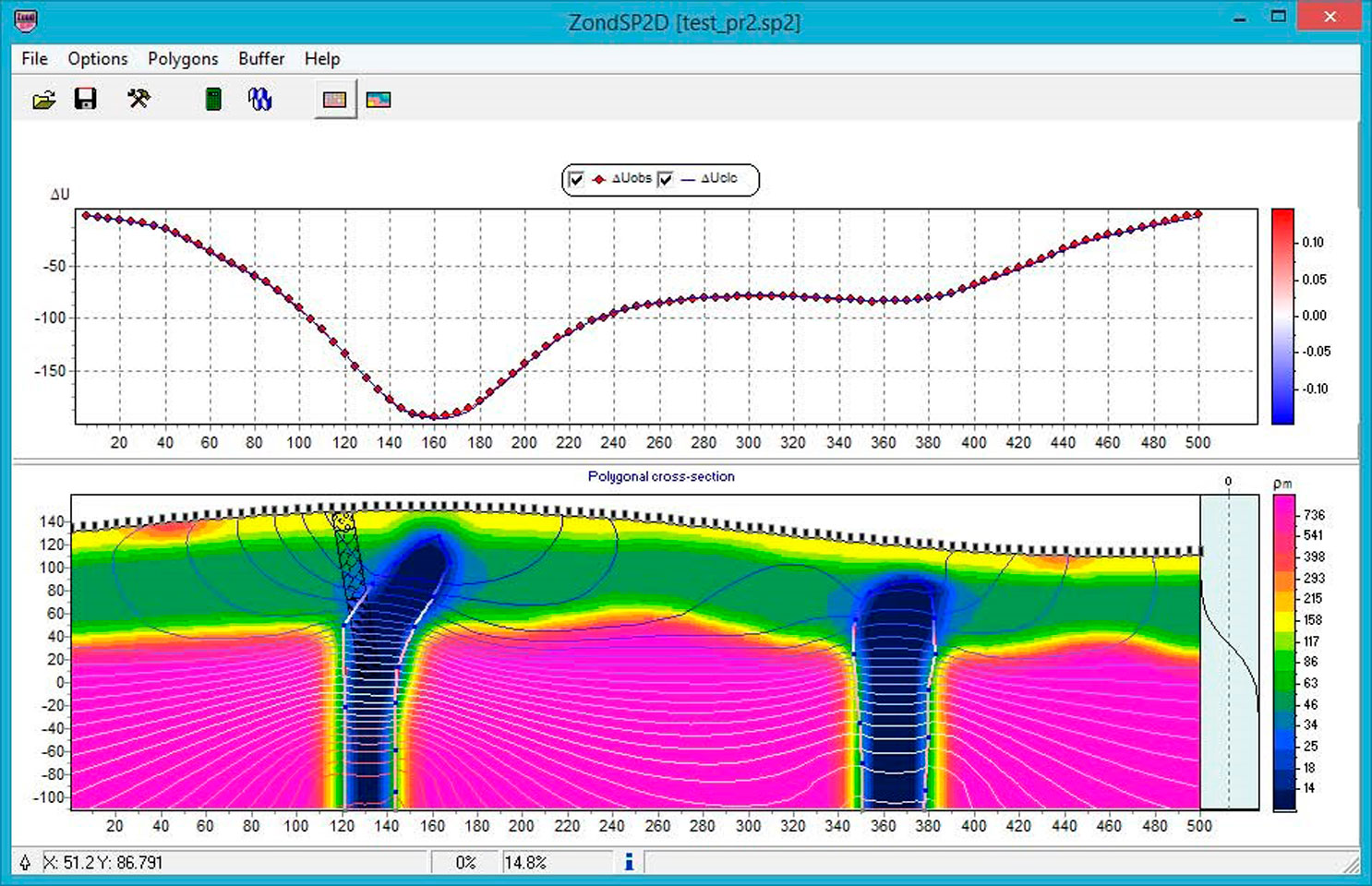
Selection of objects in polygonal mode on the basis of resistivity model calculated from ERT data with superimposing of potential isolines and a priori geological information. The graph to the right of the model shows the distribution of potential-determining factor with depth.
ZondSP2D belongs to the Zond family of programs. A unified interface and approach to data processing make it easy to familiarize yourself with operation of the entire package – in case you have the skills to work with one of the programs This approach allows interpreters to compile geophysical data from different methods, what leads to a more stable and reliable geological and geophysical model.
Zond software family:| ZondIP1d |
Designed for 1D inversion of VES and VES-IP data |
| ZondRes2d |
Designed for 2D interpretation of resistivity and induced polarization data in land, borehole and marine variants |
| ZondRes3d |
Designed for 3D inversion of resistivity and induced polarization data in land, borehole and marine variants |
| ZondProtocol |
Designed for creation of protocols, measurement control and visualization of ERT measurements and data quality assessment |
| ZondMT1D |
Designed for 1D interpretation of magnetotelluric (MT), audiomagnetotelluric (AMT) and radiomagnetotelluric (RMT) data |
| ZondMT2D |
Designed for 2D interpretation of MT, AMT and RMT data |
| ZondGM2d |
Designed for 2D multiprofile interpretation of gravity and magnetic data |
| ZondGM3d | Designed for 3D interpretation of gravity and magnetic data |
| ZondTEM1d |
Designed for 1D interpretation of transient electromagnetic (TEM) data for lines and loops |
| ZondTEM2d |
Designed for 2D inversion of EM soundings data in time and frequency domain |
| ZondST2d |
Designed for 2D interpretation of seismic tomography data (first breaks) and refraction seismic |
| ZondST3d |
Designed for 3D interpretation of seismic tomography data (first breaks) and refraction seismic |
| ZCGViewer | Designed for calculation and visualization of apparent resistivity graphs obtained with various electric survey systems |